This is a write up of David Williams’ solo sea kayaking expedition to Pearson Island in 2000.
At this point the Island had never been paddled to in a Sea Kayak.
Many people would not associate South Australia with spectacular and isolated off-shore islands.
Temptingly positioned so as to attract the seasoned sea kayaker. However is does, and it was the Pearson Islands off the South Australian (SA) coast that were calling to me. They are located some 70km off Elliston, Eyre Peninsular, in the Great Australian Bight and are South Australia’s most remote island group. The added temptation for me was that they had never been paddled to before.
So why do a solo paddle?!|Well i was fortunate enough to have been sea kayaking for a number of years as part of a small expedition group in SA. I also had the opportunity to organise a number of serious expeditions, including the first all SA expedition across Bass Strait. So, I was keen to discover if i had the skills and experience to undertake such an adventure on my own.
I had been thinking and planning the trip for about seven months, and planned to undertake the trip in January 2000 – I thought it would be a great way to start the year 2000. So after New Year’s Eve I sat at home in the Barossa with all my equipment packed and watched the weather on the net waiting for a four-day weather window. On the 7th of January, the weather looked favourable, so I made contact with Mike, The Australian Volunteer Coast Guard at Port Lincoln, to inform him that the trip was on.
I kissed my wife Vicki and my children Jami and Daniel goodbye, jumped in my trusty old ute and was off.
Arriving in Elliston the next morning at about 8.30am, I parked on the beach and quickly packed my kayak. I wanted to park my ute in a safe location so i chose the front of the local police station only to discover upon my return, and much to my amusement, that there hadn’t been any police there for months.
While I was walking back to where I had left my kayak the enormity of my challenge hit me. I started to question myself – had i really considered the risks of this challenge> was I truly fit enough? Did I really ish to do this paddle on my own?
Physically getting into my kayak and starting to paddle was one of the most difficult thing things I had done as a sea kayaker. Something I had not experienced before (a good reminder to me, as an Outdoor Recreation Lecturer, of the feelings my students must have as they strive to meet the frequent challenges of their course).
At 9.40am I slowly paddled out into the mist that surrounded the shore that morning. I was heading for Topgallant Island (named by Matthew Flinders because it gave the appearance of a square rigger under full canvas) 13.8 nautical miles away. For the fist hour I had to follow a compass bearing as the mist, combined with 2 to 3 meter swell made the island impossible to see. As the island came into view I felt at home again on the water and enjoyed watching the island grow in the distance, rising to display it’s magnificent limestone cliffs. Just before I reached the island I was joined by a small pod of dolphins. They played lazily around me, but still moved with striking speed, just letting me know how slow they thought I was.
The high cliffs of Topgallant Island were beautiful, however, it was the spectacular rock pinnacles reaching to the sky that drew my attention. A breaking reef to the south-west joined the pinnacles to the main island. A tempting playground, but as a solo paddler I felt I needed to exercise extra caution and venture no closer.
I knew there was much more beauty to come, so as it was now about 1.40pm I felt it was time to move on. I was heading to Flinders Island, an island large enough for pastoral use being approximately 17km by 7.5. The island was not named after Matthew Flinders but his brother Samual Ward Flinders, second lieutenant on board the Investigator. In the early 1800s a hermit sealer lived on the Island; he became very ill and fearing the end was near, buried his chest full of money away from the camp. So rumour is there is treasure to be found on Flinders Island.
As I came closer and closer to the island I was impressed by its coastal diversity: From rugged cliffs to tranquil bays and sandy beaches. It was really quite beautiful and I could have spent a number of days just exploring the coastline.
My camp planned for the night was 6.5Nm away from Topgallant Island in a small bay on the southeast side of Flinders Island. On my way in, I paddled past one of the local abalone dive boats and had a chat with the owner who also took a photo so he could show his mate at the local pub how crazy these sea kayakers really are!
I was happy to reach shore at 3.40pm and have a chance to explore my new surroundings (No Treasure!!)
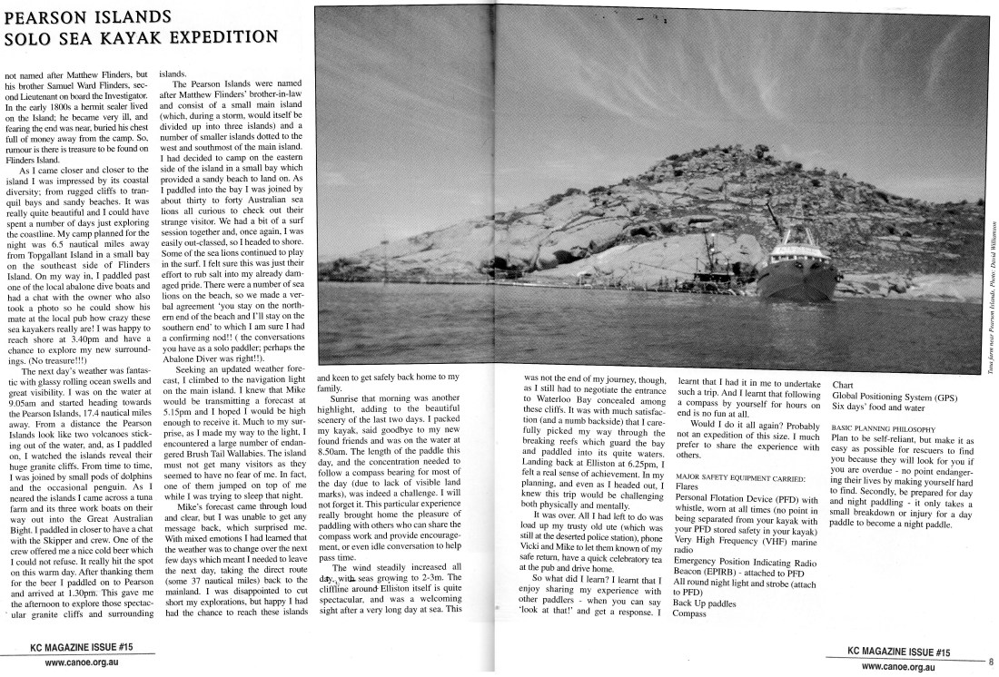
The next days’ weather was fantastic with glassy rolling ocean swells and great visibility. I was on the water at 9.05am and started heading towards the Pearson Islands, 17.4Nm away. From a distance the Pearson Islands look like two volcanoes sticking out of the water and as I paddled on I watched the Island reveal their huge granite cliffs. From time to time, I was joined by small pods of dolphins and the occasional penguin. As I neared the islands I came across a tuna farm and its three work boats on their way out into the Great Australian Bight. I paddled in closer to have a chat with the skipper and crew. One of the crew offered me a nice cold beer which I could not refuse. It really hit the spot on this warm day. After thanking them for the beer I paddled onto Pearson and arrived at 1.30pm This gave me the afternoon to explore those spectacular granite cliffs and surrounding islands.
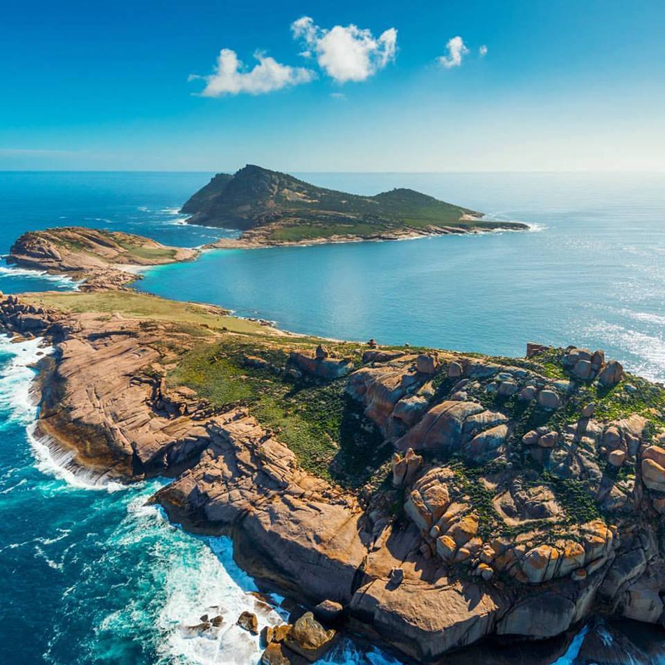
The Pearson Islands were named after Matthew Flinders’ brother-in-law and consist of a small main island (which,during a storm, would itself be divided up into three islands) and a number of smaller islands dotted to the west and south-most of the main island. I had decided to camp on the eastern side of the island in a small bay which provided a sandy beach to land on. As I paddled into the bay I was joined by about thirty to forty Australian Sea Lions, all curious to check out their strange visitor. We had a bit of a surf session together and, once again, I was easily outclassed, so I headed to shore. Some of the sea lions continued to play in the surf. I felt sure this was just their effort to rub salt into my already damaged pride. There were a dumber of sea lions on the beach, so we made a verbal agreement ‘you stay on the northern end of the beach and I’ll stay on the southern end’ to which I am sure I had a confirming nod!! (The conversations you have as a solo paddler; perhaps the Abalone Diver was right!!)
Seeking an updated weather forecast, I climbed to the navigation light on the main island. I knew that Mike would be transmitting a forecast at 5.15pm and I hoped I would be high enough to receive it. Much to my surprise, as i made my way to the light, I encountered a large number of endangered brush tail wallabies. The island must not get many visitors as they seamed to have no fear of me. Infact one of them jumped on top of me while I was trying to sleep that night.
Mikes forecast came through loud and clear, but I was unable to get any message back, which surprised me. With mixed emotions I had learned that the weather was going to change over the next few days which meant I needed to leave the next day, taking the direct route (some 37Nm, roughly 70Km) back to the mainland. I was disappointed to cut short my explorations, but happy I had had the chance to reach these islands and keen to get safely back home to my family.
Sunrise that morning was another highlight, adding to the beautiful scenery of the last two days. I packed my kayak, said goodbye to my new found friends and was on the water at 8.50am
The length of the paddle this day, and the concentration needed to follow a compass bearing for most of the day (due to lack of visible land marks) was indeed a challenge. I will not forget it. This particular experience really brought home the pleasure of paddling with others who can share the compass work and provide encouragement, or even idle conversation to pass time.
The wind was steadily increasing all day, with the seas growing to 2-3m.
The cliff-line around Elliston itself is quite spectacular, and was a welcoming sight after a very long day at sea.
This was not the end of my journey though, as I still had to negotiate the entrance to Waterloo Bay, concealed among these cliffs. It was with much satisfaction (and a numb backside) that i carefully picked my way through the breaking reeds which guard the bay and paddled into its quiet waters. Landing back at Elliston at 6.25pm I felt a real sense of achievement. In my planning, and even as I headed out I knew this trip would be challenging both physically and mentally.
It was over. All I had left to do was load up my trusty old ute (which was still at the deserted police station) phone Vicki and Mike to let them know of my safe return, have a quick celebratory tea at the pub and drive home.
So what did i learn?
I learned that I enjoy sharing my experience with other paddlers – when you can say “look at that!” and get a response.
I learned that I had it in me to undertake such a trip.
I learned that following a compass by yourself for hours on end is no fun at all.
Would I do it again? Probably not an expedition of this size. I much prefer to share the experience with others.
MAJOR SAFETY EQUIPMENT CARRIED:
Flares
PFD with whistle attached
VHF marine radio
EPIRB – attached to PFD
All round night light and strobe – Attached to PFD
Spare paddle
Compass
Chart
GPS
Six days food and water
BASIC PLANNING PHILOSOPHY
Plan to be self-reliant, but make it as easy as possible fore rescuers to find you because they will look for you if you are overdue – no point endangering their lives by making yourself hard to find.
Secondly, be prepared for day and night paddling – it only takes a small breakdown or injury for a day paddle to become a night paddle
David Williamson – 2000