Here is David Williamson’s account of the first ever attempt at crossing Western Bass Strait (Via King Island) in sea kayaks.
(unfortunately I do not have any photos from the trip, so these are sourced from google)
January 2001
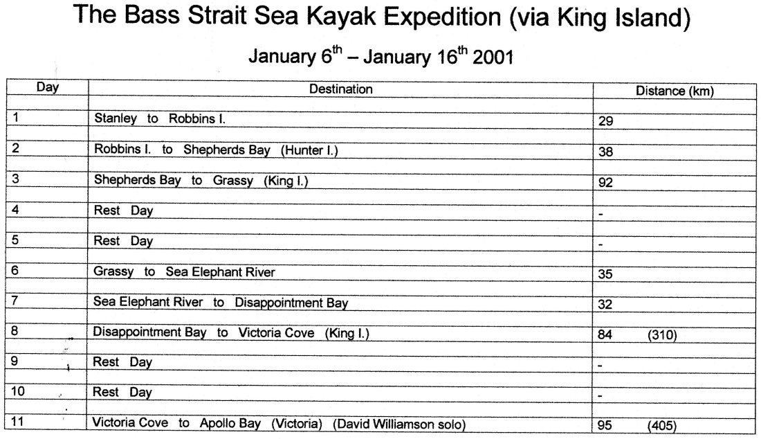
It had been over a year in the planning, Jim Townsend, Malcolm Hamilton and my self had checked everything, all our equipment had been packed and sent ahead of us by plane, and we had developed an on-water management and contingency plans which would determine how we would operate under a range of weather and sea conditions. It was only a matter of trying to complete our little adventure
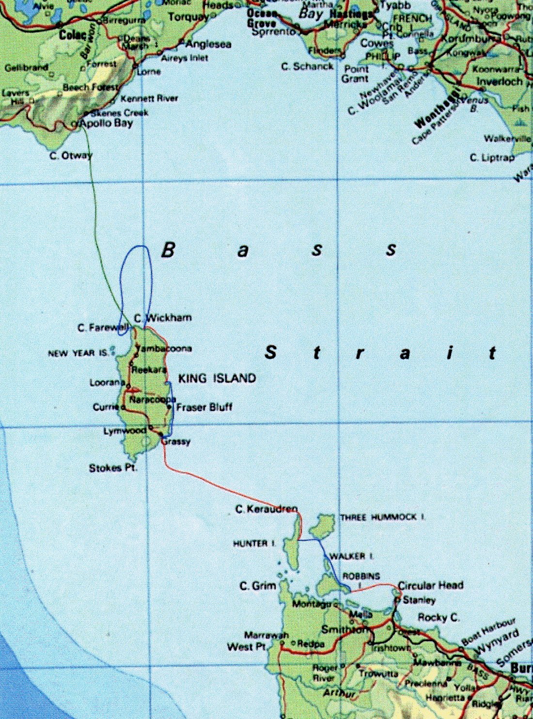
Our goal was to paddle from Tasmania to Victoria via King Island.
The Flinders Island side, or eastern Bass Strait, being the more sheltered side, with shorter distances between islands, has been paddled several times, the first of which was in 1970. Malcolm and I had already paddled this side once.
The King Island side of Bass Strait however, had never been paddled before. This is due to the reputation of Bass Strait (Often described by ocean sailors as one of the most dangerous stretches of water on the planet), the great distances required to be paddled between islands, and King Island’s interesting maritime history. It is the scene of Australia’s worse maritime disaster and has more known shipwrecks than any other part of Australia.
It was this bit of water, with a great deal of caution, that we were going to try and cross.
Wednesday 3rd of January 2001.
It was a beautiful day in the Barossa, and I was on my wat to Adelaide airport to meet Jim and Malcolm. We flew from Adelaide to Melbourne and then to Burnie. On our arrival, we discovered that the Burnie airport is at Wynyard and some distance from Burnie. Just as well we had not booked any accommodation. We walked to the Wynyard caravan park, a beautiful spot right on the beach and booked a small cabin for the night. We then made our way to the local pub for tea and a quiet beer or two.
Thursday 4th and Friday 5th
The weather window looked very good for the next few days. I phoned to find out where we could pick up our kayaks so that we could take advantage of the weather window only to be told that our kayaks were safe in Melbourne. Apparently, their Freight plane had been taken offline for servicing and it may be a week before arriving in Tasmania.
To say that we were upset would have been an understatement, especially when we had been promised that there would be no problem in the delivery of our kayaks. We spent some time investigating other ways of transporting the kayaks to Tasmania to no avail. So there we stood with a great window of opportunity and all we had were the clothes we flew in. The rest of our clothes and equipment were in our kayaks. We didn’t even have a toothbrush. We spent that day wandering the streets of Wynyard, bought a toothbrush each and some food for the next few days and contemplated all the possibilities. The next day, resigned to the fact that it may be some time before our kayaks and equipment arrived, we decided to take a day trip to Burnie, about an hour away by bus. This would give us a chance to do some sight seeing and the opportunity to investigate ways of getting our kayaks from the Burnie airport to Stanley.
That afternoon I made contact with the air freight company to check on and progress with our kayaks and was informed that they would be flown into Tassie that night, and transported to Burnie airport by truck by 7am the next day. Relieved to hear the news I told Jim and Malcolm that we were back in business. It was good to see their faces light up. We made use of Burnie’s shopping centre and bought enough food to get us to King Island safely. We made contact with the trucking company to see whether they would transport our gear all the way to Stanley. For a small charge they were happy to meet us at the Wynyard caravan park and transport one of us and our gear as well.
Saturday 6th and Sunday 7th
The truck arrived on time and Malcolm went with the drive to Stanley leaving Jim and myself to hitchhike. We walked to the highway and managed to get a ride to the Stanley turn off fairly easily and walked the remaining four or five kilometres to the harbour where Malcolm had our kayaks set up.
We had to be extra careful about the equipment we had brought with us as it all had to fit into our kayaks. There was no leaving excess items in the car on this trip! Malcolm and Jim were paddling a double sea kayak and I was paddling a single. Everything fitted!
We had a quick bite to eat from Stanley’s famous seafood café and headed back to the kayaks. There were plenty of curious people around to help us launch our boats. Some thought that we were mad, and others thought that it was a great adventure.
It was such a relief to finally get on the water late that afternoon and with a hand shake each, we were off. We left the harbour and paddled past a landform called ‘The Nut’, some 152m of sheer cliff. It dominates the headland. We paddled past a small rocky outcrop which is home to a large number of seals, then around ‘North Point’ at the top of the headland and across to Robbins Island. The near perfect conditions allowed us to practice some drills on the way across. At about eight o’clock we arrived at Robbins Island just west of Cape Elie and set up camp for the night on the beach.

Up with coffee, we listened to the ABC’s 5.55am weather forecast. The forecast was for light winds from the south in the morning, strengthening to moderate in the afternoon. We quickly repacked our kayaks and made our way up the northeast coast of Robbins Island and Walker Island to the Petrel Islands for lunch.
The strengthening southerly winds gave us a chance to play with our small sails on the way to the southern most point of the Three Hummock Island. We turned westward and followed the coast for a while, then it was across to Shepherds Bay on Hunter Island.
The strengthening southerly on our beam made it a sloppy afternoons paddle. Shepherd’s Bay is a picture postcard bay with a white sandy beach against a backdrop of thick green bushland. We decided to bivvy on the beach that night as the next day required an early start. The high tide that night gave us an interesting night’s sleep.
Monday 8th January
We were up at dawn and ready to paddle, I phoned the Tasmanian weather bureau using the trusty CDMA phone. The forecast for the day was south-easterly winds to 20 knots which was within our management criteria. Today’s paddle was extreme – some 82km to Grassy Harbour on King Island – further than any of us had paddled before. We used the tide to pull us the 9km out to Cape Keraudren. We had a short break, put on some more clothing, and headed out across Bass Strait. We were now 68km from Stanley. The wind was from a favourable direction which allowed us to use our sails, however it wasn’t long before Malcolm’s sail broke, so it was back to paddling.
My sail was working fine, so well in fact that I was starting to pull away from the double. Our management plan stated that a maximum separation of 50metres was allowed. We, therefore hooked up a tow line to keep us together and to keep our overall speed as high as possible. Every hour we would raft up and have a quick snack. Constant waves of 3 to 4 metres made it difficult to raft up for long. Malcolm had convinced us to buy special Power Bards which were supposed to renew your energy levels faster than any other bar, the only trouble was that they tasted like cardboard and were so chewy that they almost pulled your teeth out. We had been paddling now for a number of hours and had been monitoring the GPS which said we were getting closer to King Island but our landing point required us to head further and further on a northerly bearing. The current had ben pushing us due west all day, we had hardly made any northward movement at all. In fact it wasn’t until late in the afternoon when we could see Reid Rocks and the reefs around it breaking that we started to move northward. It was also at this time that Jim and Malcolm started to fight their boat. Malcolm asked me to check the skeg and I discovered some of its missing which explained why it was hard to keep on track in the following sea. It turned out to be one of those long days.
It was just before dark before we could see our destination. As we picked up the lead light for the harbour a yacht approached us, a few of the crew gave us an unusual look and then sailed on. As we paddled into the calm waters of Grassy Harbour, once a busy mining port, we unhooked our tow system and made our way to a small beach area in the harbour. It was now 9.55pm We dragged our kayaks up the beach and made camp in a deserted playground, ate some food and crashed out for the night.
We had made King Island, something that had never been one before by kayak, we had also paddled 90km, the longest paddle for us to date.
Tuesday the 9th and Wednesday the 19th
After a much-needed sleep in we made our way up to the semi ghost town of Grassy. We were going to play tourist for the day and had booked a hire car at the local store. The lady at the store was surprised to see us and couldn’t believe that we had paddled across the day before. We headed out to the southern most point of the island. On the way we stopped to watch a kelp farmer, who gruffy educated us on what kelp was used for and how King Island Kelp is the best in the world. We then admired the view of the southern point called Stokes Point and nearby which we voted ‘the best bakery in the world’ due to their camembert and seafood pies.
We had a quick look at Currie’s Harbour and Lighthouse (one of the only recommissioned lighthouses in the world. It was reopened due to the pressure applied by the local community on the government of the day), then it was off to the northern most point on the island. On the way we made a quick stop at the famous King Island Dairy for a serious tasting (delicious!). At the northern end we had a chance to check out our departure spot before we headed across Bass Strait to Victoria. We also had a look at Cape Wickham Lighthouse, the tallest lighthouse in Australia. Then it was back to Currie for some King Island steak, Jim and I couldn’t wait. Malcolm opted for the seafood. Unfortunately for Jim and I, Malcolm made the right choice. I think our steak must have come from the mainland; it was tough as old boots. Sea and weather conditions for the next day were outside our on-water management guidelines so we used the day to visit the small village of Naracoopa and revisited our bakery. The afternoon went by doing some sail repairs and rebuilding of the doubles’ skeg thanks to the help of the guys at the port. We had tea that night at the Grassy pub and were invited onboard a yacht for breakfast the next day.
Thursday 11th and Friday 12th.
We were up early (the weather forecast for the next day or two was favourable) packed our boats and headed to the yacht for breakfast. Our quick breakfast turned into a very nice, and very long breakfast and the tide we were hoping to ride up the coast had almost past by the time we started paddling.
IT was a pleasant day’s paddle allowing us to explore the coastline. We camped that night at the point where Sea Elephant River meets the sea.
The next day we paddled toe coast to Disappointment Bay, On the way we watched a large bushfire burning, the smoke was so thick and you could see the flames jumping high into the sky- it was nice to be on the water. Disappointment Bay was our jump off point to Victoria and is 65km from Grassy Harbour. We arrived there just after lunch upon calm seas. We phoned for a weather forecast. The next day’s forecast was for light south-easterly winds shifting easterly around three o’clock in the afternoon and then building to a strong wind warning that night from the north east. The wind was then due to stay up for the next few days. We discussed our options and decided that we could paddle the 95km to Apollo Bay in 16 hours. If we left at midnight, we would be in Apollo Bay before it was too windy. We also figured that we could work hard for a few hours if it started getting windy a little earlier. So, we agreed to leave around midnight if the 9pm weather update confirmed the earlier forecast. We prepared our kayaks for the crossing, ate some tea, and got some sleep. My alarm went off at 9pm and I phoned for a forecast which confirmed the previous forecast so I told Him and Malcolm that we would leave around midnight and reset my alarm.
Saturday 13th
With the alarm going off, we packed the last bit of our gear, turned our night lights on, and started paddling. The water was calm just a gentle swell, we could hear the waves gently breaking over the Navarine Reef. It was a strange night; you could see the stars and moon through the smoke haze and smell the smoke. We took it in turn (hour-on, hour-off) to follow a compass bearing with a short break every hour. We were making good time, but as the sun rose I could feel the pressure in my bowel and I realised that it was time for me to ‘relieve’ myself for the first time at sea, much to the amusement of Jim and Mal. We rafted up, I climbed out of my gear and slipped into the water and while Malcolm held the boats together, Jim paddled us away from the offending matter, all in all an interesting experience but one I would rather avoid. We paddled on, it was now about 8am and we were over a third of the way across and still making good time when we had our first puff of wind from the northeast.
We looked at each other knowing that it was much too early for that wind shift.
My heart said ‘go on’, because that was where my wife Vicki and my two twins Daniel and Jami were waiting along with Jim’s partner Kyla, but my mind said ‘it was essential to turn around now or risk putting ourselves in extreme danger from the early weather change’. Without hesitation we all agreed to turn around and start heading back to King Island.
(I think this quick decision may have saved our lives) As we headed back the wind and sea increased, it was becoming hard work. We agreed to only have a break every two hours as the conditions were deteriorating rapidly, however, we found we could not even afford this without losing too much ground.
As we paddled I was monitoring my GPS and the bearing we needed to follow to get back to King Island. Due to the sea and wind conditions, our actual course was not even close to what was required. At this rate we would miss King Island altogether, knowing that the next top past King Island was Antarctica. I paddled over to Jim and Malcolm and said that “we are not in good shape here”. They knew from my voice that things were pretty serious.
For the first time in my paddling career I seriously considered my evacuation options believing that it was a real possibility.
We then lifted our paddling rate as high as was possible in the conditions. I can remember at one stage being so tired that I had to have a rest, so I paddled over to Jim and Mal and forced down one of those super power bars and to my surprise started to feel better again and we continued paddling.
We were not paddling into very strong winds and staying close to each other was difficult. A few times I was just being the double when a wave would break and was me some two hundred metres away from them. I would then slowly pick my way back to them.
According to the GPS we were now making some headway and if we could maintain this course and speed, we would just make it into Victoria Cove, some 5km from where we had started. We slowly watched the Cape Wickham lighthouse grow. As we drew near to the island we now had to contend with ‘bullet winds’ being funnelled off the island. At this stage I made my way out in front watching my paddle flex in these winds. My concern was that we had no idea what this cove was like and whether it was possible to land there. Knowing that we were all at the end of our endurance we had no choice but to go ashore, even if it meant waving goodbye to our kayaks.
As I paddled into the cove I was what I had hoped form a nice sandy beach, When I finally hit the beach all I could do was crawl up the beach somehow managing to drag my kayak up behind me, and then I slowly got to my feet. I went down to the water to help land the double. I grabbed the front and Jim and Mal just fell out and crawled up the beach trying to get to their feet. It was now about 4.20pm After a while they too regained the ability to walk and we pulled the kayaks further up the beach, made a quick make shift camp and crashed out for a few hours.
We were back on King Island, but most importantly – We were alive!!
That night we informed Kyla and Vicki of our situation and that we would update them of our plans the next day. We went to bed early.
Sunday 14th and Monday 15th
After a sleep-in we woke to the winds howling from the south and the forecast had warnings our everywhere. Over breakfast we had a debrief about yesterday’s paddle.
Malcolm talked about how he felt physically. He believed he had it in him to paddle across to Victoria if all went well but did not believe he had the reserves of strength required if we got hit by another weather system like yesterday. On that basis, for his and the groups safety, he pulled out and decided to arrange transport home. That left Jim and I to decide what we would do. Jim felt he needed some time to think it over and discuss it with Kyla. I also needed some time to think about our situation and to talk to Vicki.
We spend the rest of the day exploring Cape Wickham. We met one of the locals who was showing his friends from Victoria over the island. He had a key to the lighthouse and offered us a look inside. The views from the top were breath-taking, you could see the wild sea and where the fires were still burning.
Later that day Jim had a long chat to Kyla, and came to the conclusion that he too would finish the paddle here. He felt physically fit, but he had prepared himself mentally for two extreme das on this trip, which he had already achieved. However, he did not feel he could adequately prepare for a third extreme day.
This left me to make a decision. Do I stop here or continue solo? I phoned Vicki and discussed my options, she indicated she would support me what ever decision I made. I felt physically well and had prepared myself, realising that it may take more than once attempt to cross. I had also done some long-distance solo trips before, so I knew I could handle the isolation at sea; so with Vicki’s blessing and with Jim and Malcolm’s permission, I decided to attempt a solo crossing.
That night we discussed how I could improve my safety as a solo paddler. I packed an extra EPIRB and VHF marine radio. My big concern was if I injured myself and could not paddle it could also mean difficulty in staying upright. To counter this problem, we rigged up flotation bags that could be clipped to the side of my boat to keep me stable while I waited for help if needed.
I was ready to go.
If the forecast was acceptable, I would go the next morning.
The next morning I woke early and phoned for a forecast – there were two fronts due through that day. So instead, we headed to Currie. We had walked about 5km hoping for a ride when we came across some council worker who kindly radioed for a taxi. Whilst waiting for the taxi we explained what we were doing and one of the gentlemen offered us a 4WD Ute and his kelp trailer to transport the double back to Currie, which we gratefully accepted. The Taxi took us into Currie. Once again we visited the bakery and then picked up a 4WD Ute and trailer. I made contact with the weather bureau and learnt that the forecast for the next day was favourable. We bough some more supplies and headed back to camp. Jim gave me the rest of his high-powered sports drinks and I went to be early.
Tuesday 16th
I woke early, phoned for a forecast, and learnt that I should have light south to south-easterly winds all day. I quickly got dressed and packed my things. Jim and Malcolm helped me launch my kayak, and with a handshake from both, I was off. It was not 6:30am. I planned to paddle the first two hours just to get into the swing of things and it was great watching the sunrise behind Cape Wickham lighthouse.
The swell was at a height of 3 to 4 metres with very little wind. After the first two hours I had a short break and a power bar (they still tasted like cardboard). I put my sail up hoping that I would be able to sail but it just flapped in the breeze so I resumed paddling, ensuring I now took a break every hour as well as some food and a sports drink. It was not long before I could not see land in any direction.
This was the first time I had paddled solo and not been able to see any land at all. It certainly made me feel insignificant I continued to follow my paddling regime whilst listening to ABC talkback radio. From time to time I even joined in on the conversation – perhaps the isolation was getting to me. At one point I could see a small trawler heading towards me, so I radioed the vessel to let them know a kayak was in the water just ahead of them. I received no reply, so I paddled hard to ensure that I was well clear of them. As I looked back at the vessel, I could see its name ‘Coral Sea’ – I hope it had someone at the helm. I paddled on. In the distance I could finally see the Otway Ranges, so I tried to phone Vicki. I got through and she was relieved to hear my voice. I told her my position and Vicki informed me that Kyla had sports drinks waiting for me. I politely told Vicky to tell Kyla “I never want to see another sports drink in my life”. She laughed. I slowly watched the mainland grow and eventually was able to pick out Apollo Bay. It was now starting to get dark; the sea had dropped to a 1 to 2 metre swell and no wind. I picked my way around Point Bunbry and into Apollo Bay harbour. I had now been sitting in my kayak for fourteen and a half hours, and with tidal movement added, I had paddled over 100km solo across Bass Strait.
I could hear Vicki and Kyla cheering from the breakwater. I felt a huge relief and sense of satisfaction, but at the same, a little sad that I didn’t finish this paddle with my friends. As I came close to the shore my 3-year-old twins Jami and Daniel came running down yelling “we love you dad”. It was hugs all round and Kyla did force a banana and sports drink into me before we celebrated with champagne.
It was over – the first crossing of Bass Strait via King Island.
The next day we started on our way back to the Barossa Valley (Jim and Malcolm were picked up that day by Kyla at the Melbourne Airport)
David Williamson, 2001
Equipment / provisions
Personal
Personally camping equipment
Spray deck and paddle, paddle park
Personal clothing – toiletries – BYO medication
Personal navigation equipment and charts
Personal Floatation Device with whistle, worn at all times.
Emergency Position Indicating Radio Beacon (EPIRB) – Attached to PFD
All round night light and strobe (Attached to PFD)
Food and water – BYO wine, camera
Equipment for each kayak.
VHF marine Radio
Flares
Kayak with pump, backup hand pump, sea anchor, back up paddle, tow line and compass.
Group equipment
AM/FM radio
Radar Reflector
Group first aid kit
GPS
Paddle plan had been sent to Australian Maritime Safety Authority using small ship reporting form (note A.M.S.A does not monitor progress. They do keep it on file, until you phone them won your trip completion)

Awesome achievement and recount!
LikeLike