Here is Malcolm Hamilton’s account of the first ever all South Australian crossing of the Strait by sea kayak.
The group of six consisted of the very familiar names: David Williamson, Phil Doddridge, Scott Polley, Gordon Begg, Tim Vogt and Malcolm Hamilton.
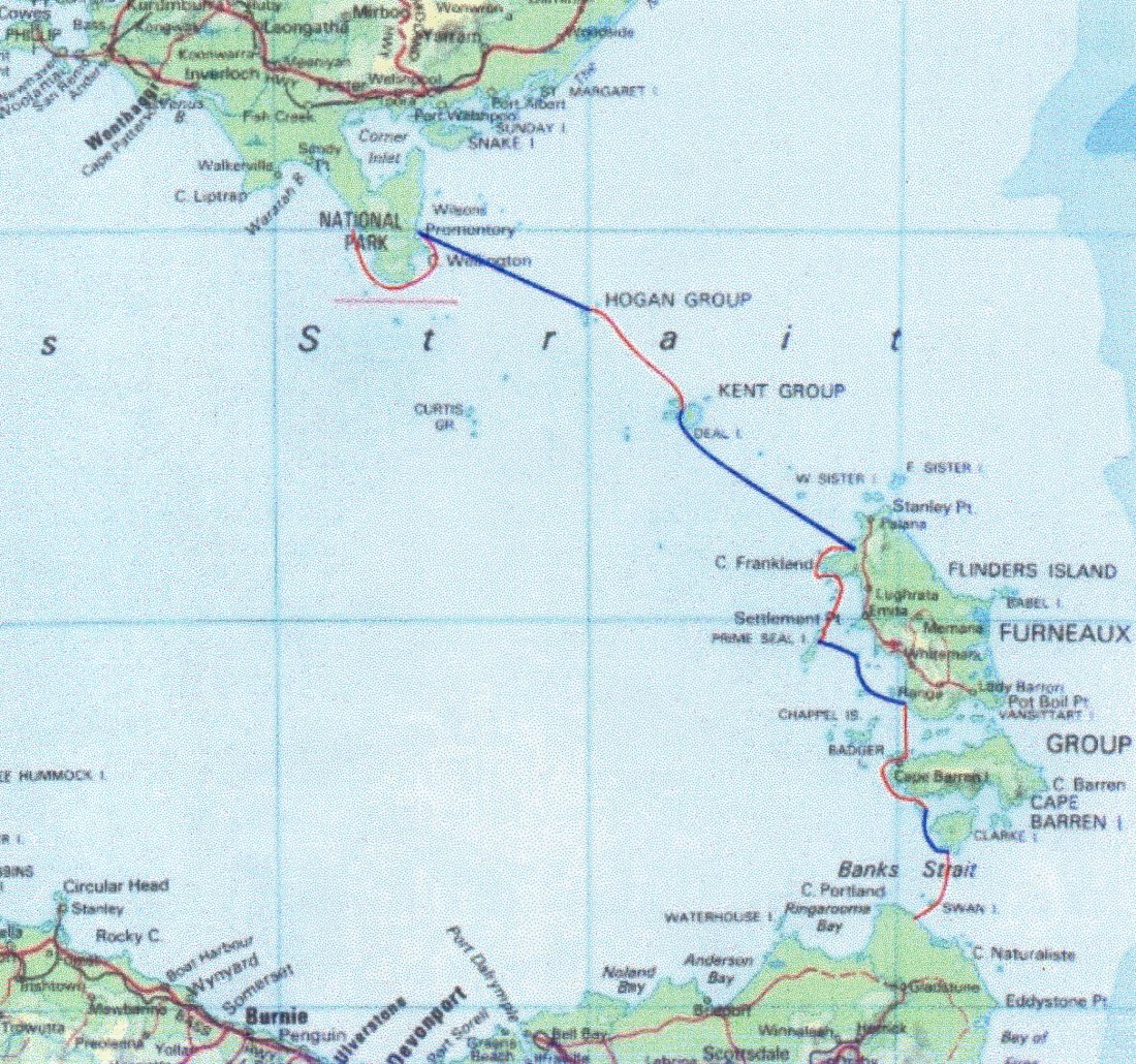
Major disasters have a way of focusing your attention on certain situations – especially when that disaster occurs in an area you intend to traverse. Our intention was to paddle our sea kayaks across the stretch of water between mainland Australia and Tasmania – The Bass Strait. Tragedy of the deaths during the 1998 Sydney to Hobart Yacht Race made us fully aware of these treacherous nature of that area.
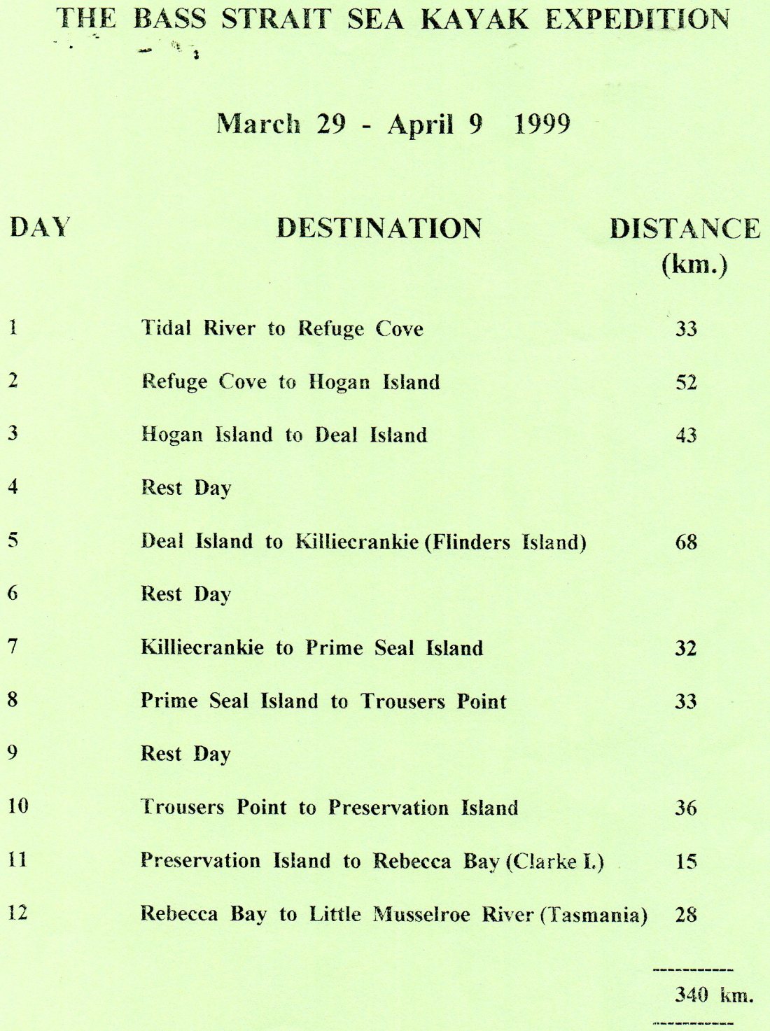
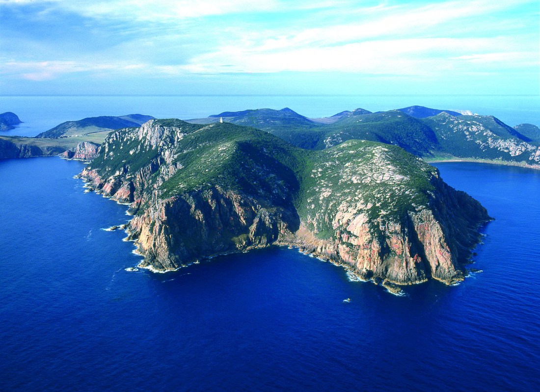
The disaster highlighted for us the necessity to be fully prepared for whatever conditions and scenarios Bass Strait presented to us, Would our preparations be sufficient? This was something to contemplate as the six of us – David Williamson, Phil Doddridge, Gordon Begg, Malcolm Hamilton, Scott Polley and Tim Vogt – stood at the mouth of Tidal River, in Wilsons Promontory National Park, surveying the surf zone through which we had to paddle to being our epic adventure.
It was almost a two-year saga of events that led us to this point in time. This group became first came together in 1997 in preparation for a paddle to the Neptune Islands with a vague idea that maybe if the trip was successful, we would then tackle Bass Strait. That trip was completed during 1998 Here.
Shortly afterwards the Bass Strait crossing preparation began in earnest. Much was learned from the Neptune Island trip that would need to be implemented for future expeditions. Four of us bought new or different kayaks. Meetings were set up, training programmes put into place, paddling days were organised, and tasks were divided amongst us to ensure as best as we could that we were prepared for Bass Strait.
We paddled out, with mixed feelings, from Tidal River, through the surf zone and all met ‘out the back’. With a final wave to our onshore watchers we headed off.
Several minutes into the trip Scott remembered he had not taken a seasickness tablet. With that sorted out, we paddled into a steady wind and moderate waves. Most of us were getting accustomed to how heavily laden sea kayaks handled the conditions. The magnificent scenery soon took our minds of such matters and we eased into a comfortable paddling rhythm
We rounded the lighthouse at the tip of Wilsons Promontory (Southern most point of mainland Australia) and pulled into a small bay with a landing and steps leading to a track that headed towards the lighthouse. Phil couldn’t resist checking out the tricky rock Landing, so he climbed ashore briefly The conditions now favoured the use of Kites and sails so the group split into two – the paddlers headed of first while the others set about getting sails and kites ready for use.
Refuge Cove was the agreed destination We all arrived at this superb location within a short time of each other. That night David attempted to make a call out for a weather check on his satellite phone, only to find that the batteries had not held their charge. This piece of equipment was now useless. So it was back to relying on the humble radio for weather reports.
The 50km paddle to Hogan Island is the second longest leg on the crossing. It is also the only leg where paddlers can’t see their destination from shore, so paddling on a compass bearing is required.
One of the structures we had in place to manage the group on the water was that one person would paddle out in front and lead the group. That person would set the pace and if required, follow a predetermined compass bearing.
We were on the water relatively early that morning and were greeted by favourable paddling conditions – a following wind and sea. Into the third hour, it was my turn to lead. The process of constantly changing from watching the compass to where I was paddling coupled with a following sea made it uncomfortable enough for me to succumb to seasickness. I took a tablet and was towed for half-an-hour until the affects of the tablet made it comfortable to paddle again. David, under sail and Tim with a kite, tried a V tow. It wasn’t long before the inefficiency of this method showed up. David unhooked his shorter row rope, allowing Tim, with a longer rope, to easily handle the situation.
Hogan Island was reached comfortably by mid-afternoon allowing us to explore the island. A walk to the lighthouse gave us a view of our departure point that morning and our destination for the next day, the Kent Group of Islands. A brief shower and the accompanying rainbow that arched over our campsite, added a special and memorable feeling to this windswept island.
It was a casual mid-morning start for the next day. The prevailing conditions were causing Scott to have problems maintaining a constant direction in his kayak. As Scott politely put it, he was having his own “Tour de Bass Strait”. Into the third hour on the water, Gordon, tired of following Scott’s meanderings, hooked him to his kayak. With Scott under tow but paddling, the group kept together reasonably well.
The Kent Group of Islands consists mainly of three islands; Deal, Erith and Dover. The Murray Passage separates Erith and Dover from Deal Island. We reached the northern entrance to Murray Passage at 5:30pm and stared in amazement at the spectacular granite cliffs. We paddled to the beach on Erith but could see no flat spots suitable for several tents. Across the passage we could see a beach on Deal Island and headed for it. In the rapidly fading light we pulled up onto the beach alongside the jetty, glad to have found a suitable place for the night.
We could do with a break, we wanted to explore Deal Island, and tomorrows conditions were only reasonable for the long crossing to Flinders Island – enough good reasons to have a rest day.
The next morning, we wandered through the island’s museum, then caught up with Bruce and Jenny, the caretakers, three weeks into a month’s stay on the island. Afterwards we walked to the lighthouse to see Flinders Island in the distance and enjoyed the spectacular views of the island group.
Later that afternoon we spoke to the police who had arrived by motor launch and the crew from a yacht anchored in the bay. The yachties had their tea around the nearby barbecue and later Bruce and Jenny joined us. It was quite a social event that evening.
Gordon awoke us at 4am the next morning. At 5.30am we were huddled on the beach for our daily briefing. Most of us set up either cyalume sticks or torches so we could see each other in the dark. The group kept a tight formation as we paddled out of the bay into the lumpy conditions in Murray Passage. We stopped briefly at the southern tip of Deal Island, then followed the compass bearing for our destination, Flinders Island. During the morning, the ebb tide had pushed us several kilometres south of our destination. However, this was more than compensated for during the afternoon when the flood tide, the following seas and the wind greatly assisted us. Well ahead of schedule we pulled up on to the each at Killiecrankie at 3.45pm – just over ten hours for what would have been a 70km paddle.
Another rest day had been scheduled. We walked to the local store and arranged for a hire vehicle for the next day’s exploration of Flinders Island. David managed to get a fire going in the camping ground’s toilet block. This heated water for a well-deserved hot shower – primitive but effective and enjoyable.
The rest day was put to good use. We checked out several areas as future campsites. At Whitemark we stocked up on provisions, then headed to Lady Barron. The Three Peaks Race was in progress, so the town had a festive atmosphere about it. Several lookouts were visited on our return journey to Whitemark where we enjoyed a good pub meal for tea. On the night drive back to Killiecrankie, Scott’s previous ability to weave across Bass Strait came in handy as he weaved his way through numerous wallabies which crossed the road – and he didn’t hit one in the process.
It was agreed to have a casual start the next day. There would also be two groups; the paddlers and the sailors and kite users. Our agreed destination would primarily be Peacock Bay or the closer Spit Bay as a back-up; both bays being on the eastern side of Prime Seal Island. The paddlers were away first and cruised the coast then the island chain leading to Prime Seal Island. The sails and kite users stayed further west, out to sea, to benefit more from the wind. When the paddlers arrived at Spit Bay beach only David and Time were there. Phil, sailing faster, had arrived earlier, headed south the Peacock Bay but finding no one there, paddled back to re-join the group.
Next morning, we left Prime Seal Island, just after 9am and headed for Chalky Island. Here the group split – One group headed to Whitemark to get supplies for a barbecue, the others headed directly to Trousers Point.
Storms clouds began to develop; there were some heavy showers. The occasional clap of thunder and lightning caused concern as the open sea is no place to be in a thunderstorm. We made good time to Trousers Point which at times was obscured from view by cloud and heavy rain.
We landed during a heavy rainstorm to find the camping area inundated with running water. Some day trippers, who were hurriedly leaving, had started a fire for their barbecue. We kept the fire going, more by good lunch than anything else. We eventually sought shelter in the toilet block until the rain abated enough to allow us to change out of our wet paddling gear.
The others arrived sometime later with their own story to tell about the same heavy rainstorm. They arrived in Whitemark in time to change into dry clothing only to be caught in the rain and get saturated again. They then changed back into their wet paddling gear for the trip down to Trousers Point. The warm fire and an enjoyable barbecue tea soon made up for any inconvenience suffered during the day.
This poor weather looked like it would prevail for a while so the next day would be a rest day. Weather permitting, Time David and Scott would climb Mt. Strzelecki. Phil would walk with them for a while then continue on to Whitemark to phone for a predicted forecast for the remainder of the trip. Gordon and I intended to laze around the camping area.
Most things went according to plan for the rest day. Phil returned with a positive forecast; good for a few days but with a possible sever change late in the weekend. Today was Tuesday so we thought we’d like to cross Banks Strait by Saturday by the latest.
The next day’s schedule revolved around the tidal movements in Franklin Sound. We were on the water just after midday and had a comfortable paddle to the town of Cape Barren This was our lunch stop and to fill in time while waiting for the tide to change we all eventually made our way into town. There was a telephone near the store, so the final phone calls were made to arrange puck-up times. By late afternoon we were on the water again. The rock gardens along the coast made for an adventurous afternoons paddle. It was getting late, but the tide and favourable seas and wind allowed us to push on to Preservation Island. We arrived just after sunset.
Next morning we crossed the Armstrong Channel to Clarke Island and found more enjoyable paddling amongst the rock gardens along its coast. Spike Bay was stunning with its granite monoliths. Rebecca Bay, or destination for the day, was equally impressive.
The afternoon was spent exploring the area. From nearby Lookout Head, we could see our final destination, the north-east coast of Tasmania. On our return we found that Gordon had cut his finger deeply while snorkelling. Scott reciprocated Gordon’s earlier towing favour by bandaging his finger. Some time was also spend planning the crossing of Banks Strait as we needed to get the timing right to handle the three-knot tidal stream.
We planned to get away by 8:30 in the morning but trying to get some interesting on-water group photographs delayed our start until 9. The lighthouse on Swan Island was our intended destination as we paddled out into the last part of the ebb tide. About two-thirds of the way across, the tide changed – the flood tide now began to take effect. Its influence was so strong that we had to change direction considerably and head for the closest beach on swam Island. The group rested for a while then pushed around the top of the island into the tidal stream. It was an exhilarating and challenging time paddling and weaving through rocks and standing waves in a long tidal stream. We landed at Jetty Bay then waked back to the lighthouse where we met Nigel, the Islands’ caretaker and weatherman.
The final run to Tasmania was with the assistance of a full flood tide. We eventually found the small entrance into Little Musselroe River and paddled quietly through it. The group negotiated the shallow water to finish at the camping ground. One elderly camper volunteered to take a group photograph for us with all our cameras. Our ground crew wasn’t expected to arrive until the next day so the same gentleman organised a ride into the nearest town for us to get some drinks. We celebrated quietly well into the night and reflected upon the many highlights that occurred during the crossing.
Malcolm Hamilton, 1999