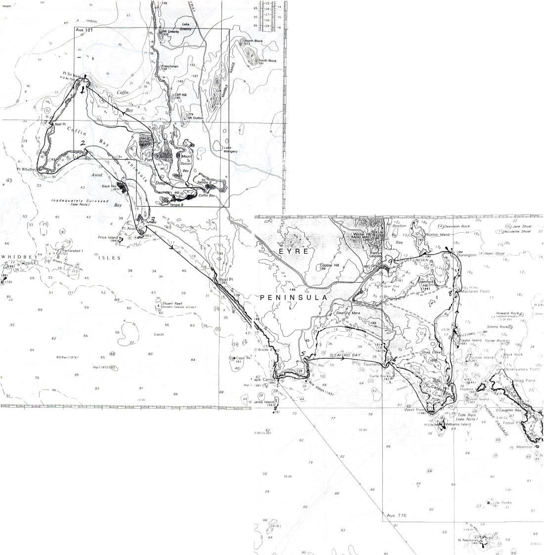
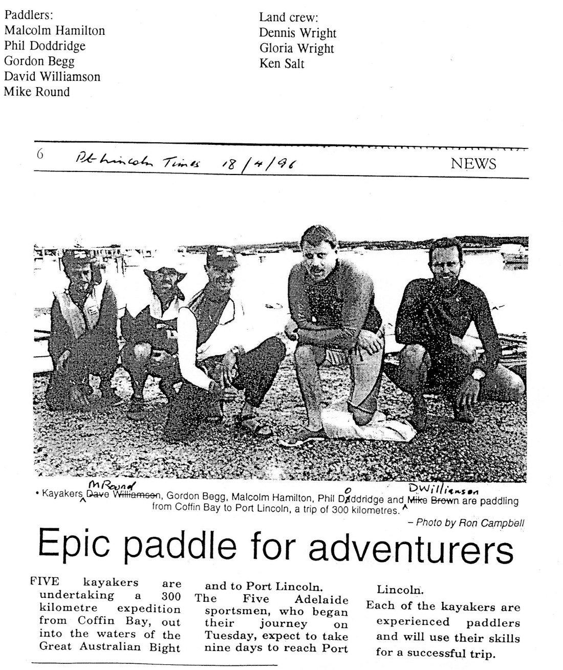
Here is the account, or should I say story of the first ever trip from Coffin Bay to Port Lincoln in sea kayaks.
The author is a man named Mike Round who was on the trip.
Although this exciting story is long, it truly captures the essences of the expedition, and is easy to imagine yourself right there along side the group.
“What? You cant canoe there! The waves are as high a church!”
“I hope you’re talking about the roof and not the steeple!” I replied..thinks hopefully…or did you mean the pews?
As the prophets decreed it soon came to past that and expedition consisting 5 paddlers and three land support crew, would set forth from Coffin Bay follow for 240 kilometres in the footsteps of its seaside equivalent, of Matthew Flinders and Nicholas Baudin around the southern coastline of Eyre Peninsula. But First…
…I was in Coffin Bay phone box to make a couple of phone calls to try and recover my glasses; missing somewhere between Adelaide Airport and Port Lincoln. SWIPE THE CARD. I Tried and nothing happened. I Tried again. Still nothing. Again in a different way but with the same result. I looked carefully for the small print, no problems since I’m short sighted, but there was none. Maybe this card precedes swipe technology I thought. Do they mean SWISH the card? I tried swishing. Again nothing. Should I be rap dancing while swiping? Next morning, no-one could get their cards to work. And no wonder, someone had excavated the cable!
Tuesday 16th April. Coffin Bay to Point Sir Isaac (34km)
I had resigned myself to making the first authenticated out of focus kayak trip between Coffin Bay and Port Lincoln, consoling myself with the thought that, as the least experienced paddle it in the group, I should be happy just to survive the journey. But as luck would have it, David lent me his spare glasses and they were almost perfect! We were looking forward to it promised to be a fairly warm day and after some press photos, we said goodbye to the shore crew and set off through a narrow channel and out into coffin Bay. I paddled along practising body rotation when I thought of it. This is the approved and proper paddling technique and means you should end up with a sore back rather than sore arms at the end of the days paddle! we stopped for lunch on the tip of point long nose, a long narrow sand isthmus which pokes over 3 kilometres into the Bay. The northern coastline and hills looked extremely clear and distinctive. After lunch we headed straight across the Bay, well out from the shore towards point Sir Isaac. We saw three Dolphins before lunch and a seal after and this was really just a taste of what was to come. We were fairly sheltered from a southerly 10 knot breeze and a couple of kilometres south of the Point, we landed on a long beach where we had seen the land party signal to us that they were setting up camp. There wasn’t much time before dark so I quickly set about preparing for the next day’s journey which would take us out into the swells of the Southern Ocean along the western coastline of the coffin Bay National Park. Sounds swell to you? I was still recovering from the previous week of feeling unwell, so I went to bed straight after tea to help my recovery for tomorrow. Forecast was for good weather, but I still felt apprehensive.
Wednesday 17th. Point Sir Isaac to Misery Bay (36km)
I put on my knew near print long Johns for the first time, and a woollen jumper that Gordon had lent me, thinking that if anyone was going to get wet it would be me. Malcolm was getting into his wet suit as well and when I asked why, since the day was going to be quite warm, he replied that you can never tell if you’re going to get wet, which I took to main cap size. All true I suppose but I didn’t really need reminding. We set off at 8:50 AM and headed north for the point. We paddled west past Seasick Bay and the light on the point and then swung around to the south with the ocean swell coming from the right front quarter. Nearly 3 hours later, Malcolm and I rafted up at the northern end of Houseboat Bay so that I could get into my CAG as I was getting cold. We landed on a steep narrow beach, moved the boats to dry sand and rocks and climbed up a small cliff to join the 4WD support party for lunch. You’ll read more about this wonderful innovation for sea kayaking trips along the wild coastlines. I was nearly back to full health and so, not to take any chances with it, decided to get dressed into all dry clothing for lunch. What a business. First, a fight with my wetsuit, starting with the main zip, handily placed behind the wearers back and jammed into my thermal singlet. Then a further fight to remove this rubbery second skin over my feet after forgetting to undo the ankle zips. No sooner had I eaten lunch and it was time to reverse the dressing procedure. Relaxing in damp clothing would have done the body more good I decided. We pushed out through a low surf and continued heading south for point Whidbey. Once we had rounded the point, the swell was coming more on the right beam and with a bit of messy chop. I was too nervous to reach down and adjust my skeg which helps control the direction of the boat and seemed to gradually move further out to sea away from the others despite attempts to steer by edging the Hull. Two- or three-times waves crashed over my back deck. Would anyone hear me shouting if I went over? ‘Stay relaxed’ I keep telling myself. It’s one thing to know that a tense body can end in capsize but another thing to stay relaxed. Staying relaxed takes a bit of effort. Probably I was not so far away from the others as I thought. Sitting so close to the surface of the water probably leads to over estimation of distance. Later on, Phil came out to join me I began to enjoy the paddling again. Several kilometres further on at the headland of Misery Cove, we crossed a reef that separates the head land from an island 200 metres offshore. The crossing had a foaming 2-foot chop along with the swell. Just when I thought I had gone past the worst of it I capsized. Capsizing almost always involves an element of surprise for paddlers, who don’t normally however allow themselves much time being entertained by that sensation. Once upside down, it’s a matter of allowing themselves much time being it’s a matter of either attempting to roll up or release this product from the cockpit and getting out and surfacing so that breathing may be resumed and outside help sort. Rescues involve the rescuing paddler dragging the flooded kayak over the deck of his own boat, turning it upside down and emptying it and then returning it to the water and supporting it for re-entry by its sodden owner. After this operation, carried out on this occasion with no fuss by Malcolm, we headed into Misery Bay and I went over again in 18 inches of water next to the beach. The beach here is known as Sensation beach. Seasick Bay, Misery Bay? I don’t know who named them, but a beach is a beach by any other name. If you like these names and perhaps the feeling of foreboding that they convey, don’t worry there’s more to come.
Thursday 18th. Misery Bay to Point Avoid (20km)
Today would be spent crossing Avoid Bay and we left the beach through a small surf and paddled along about 1.5 kilometres from shore. At one stage three Dolphins swam around Malcolm’s orange Skerray while the rest of us sat back in our white hulled boats and looked on. We eventually reached the Black Rocks and approach them on the mainland side. The rocks are small rocky islands with their cliffs undercut by the sea. A white breasted sea eagle flew slowly over. In the lee of the rocks we were entertained by a curious Seal which gave occasional snorts like large dog only much louder. Towards the end of the day’s paddle we spent some time in close to the western side of Golden island and saw four Cape barren geese fly over. The other large birds we saw on the trip were a distinctly black and white bird I think was a Gannet found in these waters, and some brown birds like Shearwaters (Mutton Birds) and Pacific gulls. These large gulls were generally near to or on beaches and were very unbothered by our close presence.
As on the previous day, we had to cross a reef that stretched between the headland and an island, this time Golden island. The swell, the reef and back swell from the headland combined to produce a confused looking sea, but the crossing proved to be more straight forward than I had feared. As soon as I came to the beach, I saw David doing headstands in shallow water while still wearing his kayak. What was he up to I could not understand but it did mean that the land support party could no longer say “there goes Michael again” and anytime they saw a white hull upside down in the surf in future they would need to have a second look.
Still, I would be giving them some more opportunities for practise. It was only early afternoon and I put some of it to use getting the boat prepared for the following day. Just before sunset, the sun came out for the first time that day and cast a brilliant glow on Golden island.
The route to the next landing spot would take the support party virtually back to port Lincoln so amongst other things for them to do their, I gave them the first three days of my diary to post to my family, and I request to buy some Silicon sealant. The support party consisted of Kevin Salt in charge of a fawn 4WD Toyota and Dennis and Gloria Wright driving a white one. Gloria is of course Malcolm’s sister and this whole wonderful arrangement of joint expeditions involving 4WD’s and sea kayaks along deserted coastlines demonstrates the purpose and value of in laws. It was Malcolm who dreampt up this expedition and who was overall in charge. Most of the time. For his small fee I can tell you that he runs blue water sea kayaking and would be happy to take you out in the Briny! The support party generally spent several hours a day navigating on tracks suitable only for full drive vehicles and mules. Each night and morning, the land party would set up a meal area and cook meals far better than any I ever experienced in similar conditions. These were eaten in drawn out fashion as we sat around with the background of good but restful music, thanks Dennis for a great selection of tapes. All the paddlers had to do was pitch their tents.
I’m still not sure who enjoyed their day more; the land party or the paddlers.
Both equally I’d say. I noticed the others often help clean things away after tea, but what, with both a lack of expertise and a fear of getting in the way and a curious idleness that struck me after tea, I admit to lying low on most of these occasions . We didn’t stay up late that night
Friday 19th. Point Avoid to Red Banks (40km)
A big day today with no landings as we would be passing 15 kilometres of surf beach and 25 kilometres of cliff. You can always land one way or another on big surf beaches I’ve been told but whether you can get off them again is another matter. This beach also had no vehicle access to recover stranded kayaks. I had slept a bit restlessly, so Malcolm didn’t exactly get a “top of the morning to you” greeting when he woke me at 5:30 AM.
A big day and we all seemed to sense it as we ate bacon and eggs for breakfast in silence. After longish while of this, it was Gordon who said “could we have the radio on please Ken? Something to break up the mood?” This struck the right chord and we all laughed just a short quiet-ish sort of laugh of course, as appropriate for the situation. We prepared salad sandwiches for lunch and stocked up on Muesli bars and lollies. I got into my thermal long sleeve singlet, light woollen jumper (still wet), long Johns, damp woollen bike pants, thermal head cover and surf shoes. Forecast was good; 0 – 10 kt winds.
We paddled out through small surf and headed across the bay towards the start of the cliffs at Shoal point. Just offshore, four or five Dolphins came near the boats. About 2 hours later when I was paddling along in front of the others, I saw a pod of four or five Dolphins about 60 metres away and sure enough they came over to my boat. They swirled back and forth under the bow and created quite a stir on the surface of the water. Three times the hull was brushed as they passed under and I wondered if it would be possible for a dolphin to tip the boat. I think that Dolphins really come to visit the boat for being all smooth skinned and shiny, rather than the boats occupant. As Phil later said, the boats could look either decidedly male or female to a dolphin depending whether the skeg is up or down . Maybe the thought of being tipped over by a bull dolphin was not so crazy after all. Maybe Dolphins do somehow sense that presence, who knows? All I know is that visits from Dolphins more than make up for my uneasiness I might sometimes feel well out on the water.
We were a long way offshore, aiming directly for Cape Carnot. The sea was smooth apart from the swell and I felt happy staying out but we went inshore at the start of the cliffs. The surf at the end of the Bay looked big but we only had to contend with a bit of back swell from the cliffs. It was more comfortable further out. Purely out of interest in rock climbing and shipwreck Mariners, I kept a look out for any line of weakness that would offer an escape route, but not anywhere along the 25 kilometres of cliffs could I find a single one. We sighted Red Banks and after some uncertainty, identified the jutting narrow promontory of rock behind which we would soon be landing. During the day we paused every hour or so for short rest generally rafting up. Not everyone necessarily joined the raft at each raft up, but I generally prefer to as it removes any fear of tipping over while you are resting and eating. Breaking up the raft can feel a bit tippy though, until you are sufficiently away from other boats and used to your paddle. After one raft up in particular I felt a bit disorientated among the swells and queasy in the stomach . I think this is because I’d had no attention to and lost my sense of the horizon while rafted up. During the last raft-up of the day, Phil got out of his Voyager and went in for a swim to stretch, while I decline the invitation to follow him. If only I knew how aching my back would be during the last 10 minutes of the day’s paddling I would have gladly accepted.
We rounded the rock promontory and paddled in to the left of two narrow inlets with a following choppy sea. Malcolm was close by, telling me to stay focused until I had landed, and to look behind for coming waves. Just what was I supposed to do with the waves once they got to me? I wasn’t quite sure and my mind was now blank.
I felt that those few minutes of pain before landing were almost the hardest I’ve endured but maybe that’s because the latest trial with its incumbent pain always seems to be the worst. In hard land events though, you can almost always stop to ease the pain if you want to. I think it’s just more difficult at sea, at least it is with my current level of skill. “And let’s face it, you’re just not fit Mike”.
We had been out for nearly eight hours; double the longest time I’ve ever sat in a kayak. On landing we were greeted with the smiling faces of Dennis, Gloria and Ken, and handed cold beers. I told Malcolm that I needed appointments with three professionals – a chiropractor, a physiotherapist and Malcolm suggested a psychologist, which had us both in fits of laughter.
“You wouldn’t get me out there!” said Dennis,
“then who’s going to paddle this thing tomorrow?” someone replied,
“nothing can stop me now” I said to Malcolm “surf, slop, nothing!”
Malcolm was pleased to hear the enthusiasm, but seemed maybe a little cautious in his response. Phil went back in and entertained us with a bit of stylish canoe surfing. The beach was only a few metres long and we carried the kayaks over the rocks to dry sand below a low cliff. We were now on the private reserve Whalers Way.
The campsite was set in a flat area amongst clean sand dunes and about 80 metres back from the beach. Each landing would see me emptying many litres of water from the enclosed hatch of my kayak. Later that afternoon I sealed the front hatch with Silicon sealant before bolting it closed. For the next 2 days coastline, the coastline would be more broken with granite headlines poking out from the limestone cliffs. I was looking forward to the shorter paddling days mainly because it would allow more time for exploring the Bush. Little did I anticipate just how short one of those days would be.
Saturday 20th. Red Banks to Fishery Bay (16km)
We break-fastered a bit later than usual and spent some time driving and walking around to look at some of the features of the shoreline cliffs of Whalers Way. These are the most spectacular and highest cliffs on the Eyre Peninsular with waves as high as churches according to our previous commentator.
We read memorial stones of two young people who had been washed off different granite headlands on the same day in 1970-something. Was it the same wave I wondered, as we drove back to the camp discussing the meaning and cause of freak waves.
Today we are blessed with the mildest of swells for this southern coastline. I was told that this situation could be attributed to the northerly winds that were forecasted to rise to 20 knots and signalling the arrival of a cold front. For the first time, I took my camera out, nothing fancy of course, just a reusable panorama Instamatic. We initially paddled close to the cliffs which kept us out of the wind and entered a spectacular chasm with a natural vertical shaft opening into a sea cave. Paddling into the cave would have offered quite a sight but I didn’t go in, fearing as usual, that a big swell would come in and lift the boat, bonking my head on the roof of the cave in the process. Not long after we left the chasm, we saw a seal that jumped completely out of the water. Someone said it had a fish in its mouth.
We paddled around Cape Carnot and landed on Cowrie Beach, a small steep beach with no road access and containing many bits of driftwood, but no cowries (a type of sea shell).
We paddled out through a dumpy low surf. Soon after, Phil went further offshore with his Voyager under sail and was really trucking along. Some time later he returned and greeted me with the news that he had just had “One of life’s great existential experiences – Sailing along with the company of 5 Dolphins on each bow!”
Phil’s second and our main highlight of the day was paddling through the very narrow channel between the cliffs of Cape Wiles and two small rocky islets. Some seals were asleep in the water while others slept on rock ledges nearby. Seals sleep in the water by floating on their backs, perfectly balanced with their flippers, noses and tails sticking up out of the water. The floating seals woke with a start but were obviously relieved to see that were were nothing more harmful than kayakers. We stayed in their company for a while before paddling the final two kilometres to the popular surf beach at Fishery Bay.
I fell asleep before tea and, waking up feeling quite bright and energetic, went off to explore in the scrub. Fishery Bay is run by the Pt. Lincoln council and apart from good dirt road access open to conventional vehicles, the site has no facilities.
The each is well used by surfers with waves up to 2-3m. Only one small group of friendly marooned surfers was camped at the bay for a duration dependent on their mother’s intentions. Unburied toilet paper almost everywhere you walked would be my only lament for the whole trip. Listening to the Crow’s drubbing of Hawthorn that night put the forecast for strengthening SW winds and rising swells temporarily out of our minds.
Sunday 21st. Fishery Bay to Cape Tournefort (16km)
Today was declared a rest day because of the forecast change in weather and rising seas. Ken took Gordon into Port Lincoln, less than 40km away across the narrowest part of the peninsular, so that he could get some attention at the hospital for a throat abscess that had put him on an almost liquid diet for the last couple of days. I went along to phone home and to enjoy contemplating the quiet waters of Seaford Mere as we drove past. Arriving back at camp, Malcolm advised us to get ready to leave straight after lunch to paddle to Cape Tournefort because conditions were holding.
The afternoon was an interesting paddle with a 2-3m swell on the right beam and some chop. It really felt like being on ocean waters. A highlight of the whole trip was when we rafted up for 40 minutes and drifted several kilometres offshore across Sleaford Bay, with Phil and David’s kayaks on our let and right with their small sails up and with the rudder of David’s Seafarer steering us towards Cape Tournefort. After separating, we continued paddling towards the cape and, after rounding it, had a following sea. Soon after, I had an episode of capsizes. As usual, the first one took me by surprise, but with a strange resignation taking over as I found my self entering the watery domain.
Phil came to the rescue and I was soon back in the boat. Phil anticipated the next capsize, which happened only moments later, and paddled over so that I could roll up off his bow. This all happened not far from the cliffs of the cape and a bit over a kilometre from our landing spot.
Not long after, I went over again – following seas never were my strong point! To break the monotony I attempted a roll but failed. Phil came to the rescue again, and when I was back onboard, we completely emptied the cockpit of water. Whether it was that, or Phil’s advice not to overdo the stern rudder but to keep up speed and reduce the turning effect of following waves, I don’t know, but I capsized no more and landed after broaching in low surf.
The beach here is about 400m long. We left the boats well above high water mark and went to the camp site set high above the dunes in a nice open place. I walked to wards the end of the cape in failing light but got a good view of Cape Wiles with its two rocky islets which we passed the previous afternoon. Maybe a photo in the morning I thought, but gave up that idea as I got lost in thick scrub on my way back to camp which I reached after dark. Funny to get lost on foot when you’re following a 4WD track, but when I reflected on this to Ken, he told me that the same thing had happened to him – while driving!
We had a merry conversation after tea that night. I can’t think what about, except that Malcolm’s renaming of Cape Tournefort as “Cape Tawnyport” probably had something to do with it.
Tomorrow’s plan was to paddle around Cape Catastrophe and north along Thorny Passage with the in-going tide.
Monday 22nd. Cape Tournefort to Memory Cove (25km)
Both before and after breakfast I took the long steep walk down to the beach to continue devotions to my boat, this time to seal the rear hatch with silicone sealant. Now the boat must surely be water tight! Malcolm brought my lunch down and we all carried the boats to the water line The surf was up a lot from the previous afternoon but I was more concerned with what might lie beyond. The Notice To Mariners on the Admiralty chart of the area warns of “…dangerous races off Cape Catastrophe…”and that “…violent rip tides exist in the vicinity of the islands between Cape Catastrophe and Thistle Island…”
Gordon launched his Nordkapp and with his usual un-fussed style, paddled out beyond the three lines of breakers. Gordon’s paddling seems never to alter in style or strength regardless of what the water is doing around him. However, when I mentioned this to him, he assured me he did put some extra effort into his paddling on that occasion.
David launched next and then Phil, who spent time after breakfast studying the wave pattern. We were at the western and quieter end of the beach but the green waves that seemed to rise without warning to confront us as the third and final break were high enough. Malcolm pushed the Voyager off the beach and I paddled out through the white slop to the first break. I capsized – but with no surprise this time! – and felt relieved to finally get out of the boat. I spent a long time trying to swim with the boat to shore but seemed to get nowhere. Finally Dennis signalled me to let go of the boat and swim in as we were drifting towards the granite boulders at the end of the beach. Phil surfed back in, told me to grab hold as he passed, which I did, and landed on the beach only a few meters from the rocks. My kayak landed on a small patch of sand between the boulders.
Phil said the surf was near his limit and thought that I should stay ashore.
Malcolm thought that I should have another go but I needed a rest. Malcolm made two attempts to get out, capsizing, rolling and capsizing again. We both ended up staying put as the others got the radio message to leave with out us. I felt a bit upset and I suppose that Malcolm felt the same, but as he said “there’ll always be another day’. We both agreed of course that the surf had risen since the time that Gordon launched nearly and hour earlier – but it had!
Dennis was a bit peeved to see that Malcolm and I hadn’t started any move to carry the boats to the other end of the beach for loading while they went to find the track that led there. Just as we were about to leave in the vehicles, we saw two huge waves, at-least 4 metres high, crash onto the beach. Maybe the sea was trying to tell me something. We drove around to West Bay and, confronted with a steep step down to a rocky beach with waves and no exposed sand, didn’t attempt to launch but drove to Memory Cove and arrived at 3pm. It was high tide with a narrow beach of dry sand. I took the boat out to practice rolling and paddled out to greet the others as they entered the bay.
A friendly woman camped nearby came up to talk to them after they landed. She had previously seen the kayaks offshore at Whalers Way. She was genuinely excited about the trip which couldn’t help but make everyone feel good. From all accounts, today’s paddling had undoubtedly been the hardest sea conditions of the trip with big following seas and with difficult conditions around Cape Catastrophe and in Thorny Passage. Maybe it was good for everyone, not least myself that I wasn’t able to get off the beach that morning. Earlier on that day, David had to cut short the two-way radio contact with the shore party, normally held every two hours or so, because of the difficult sea conditions.
The camping area at Memory Cove is very pleasant. The site has five campsites and is restricted to 15 vehicles a day. Only 4WD vehicles have access. Today’s passage and the rest of the trip passed around the Lincoln National Park which also includes all the smaller offshore islands not cleared for grazing. Phil remarked how he liked the trip because every day had different paddling conditions and highlights. From now we would be paddling more sheltered waters.
Tuesday 23rd. Memory Cove to MacLaren Point (20km)
The forecast was for 5-10 knot NW winds increasing to 17 knots. Phil and David got away early to go to Thistle Island which rises to over 700 feet (Over 200m) with spectacular cliffs along much of its coastline. Phil was keen to have a closer look at the cliffs and also wanted to do the extra distance so that his voyage would clock up 250Km! Phil’s background includes a bit of canoe surfing and a lot of canoe polo – he was a member of the successful Australian senior men’s team in canoe polo and is currently State coach. This was his first long coastal trip. David had paddled to the island last year with Malcolm on the first stage of their gulfs crossings to Wirrina Cove via Wedge, Althorpe, and Kangaroo Islands. Malcolm’s other major kayaking exploit was to paddle around the coastline of Kangaroo Island.
After Phil and David left, I walked around on the granite rocks on the north side of the bay and approached a photographer Peter Dobre, and who I took to be Ken. Peter pointed out two seals in the middle of the bay and I offered him the use of my kayak if he wanted to go out to meet them. Malcolm walked up and seemed a bi anxious for us to be leaving. I wondered why the hurry but the explanation for this and some of his later behaviour I only worked out in retrospect later that night!
Gordon, Malcolm and I paddled out of the bay and headed north along the coastline. We were now protected from the direct SW swell of the Southern Ocean but, like the others, faced a NW wind which increased throughout the day. We paddled out to a landing spot just west of the northern tip of Taylor Island and stopped for lunch. We spend an hour there and walked up the cleared ridge to look out for David and Phil but could not see them. We paddled over to Owens Island, a small and un-spoilt island belonging to the national park, and shortly after, sighted David and Phil. Phil had his sail up and was crossing over to our position. They were pleased with their mornings work which had them coping some fairly arduous sea conditions in the exposed passage over to and along the coast of Thistle Island. We all remained together while they had lunch and then set off for the final 8km to camp. After two more hours of paddling, I suggested to Malcolm that we pull into a nearby beach to explore. Malcolm seemed to have other ideas and we pushed onto where he suspected the campsite would be. Not long after, we spotted the shore party signalling to us. We turned back – It turned out that we had both been talking about the same beach.
We arrived on a very scrubby shoreline typical of the whole eastern coastline and walked up to the campsite only to be told, in good humour but with obvious purpose, to keep out of the kitchen. Unsuspected by any of the paddlers except for the scheming Malcolm, a coupe of hours of madness was about to begin! Malcolm had been under strict instructions from the land crew to gut us to the campsite – not too early and not too late! Still suspecting nothing, we settled down with drinks and reclined in chairs with the easy manner of those to the manor born. The tables were set rather formally (Candles, etc.) and with places only for six. (Dennis later explained that the sixth place was for Ron from the media but who was unable to join us.) In due course, the support crew came to the table formally dressed, the male staff in white shirts, tuxedos and bow ties, herself in a stunning ensemble with, if my memory serves me correctly, a gold tiara!
Oysters Kilpatrick with martinis and olives were duly served.
A printed menu! Shiver me timbers!
We were up to the occasion. Our casual if not tired dress added to the incongruous scene. Chicken entrée and homemade soup were served. The normal protocol for kitchen staff – or culinary personnel and waiters as they prefer to be called – is to retire a respectful distance from the table between serves. Whether it was our easy-going, almost expansive manner or something else that was encouraging them, I don’t know, but whatever it was, the staff seemed to hang around the table a lot more than protocol demands. Without considering the long term possible social consequences, we invited them to sit down and join us for the main course, centred on beef. “But just this once”, counselled Gordon, “Don’t go getting any ideas that you’ll be doing this every night!”
After cheeses and port and just and just before retiring, Dennis and Ken both felt compelled to remind us that the preceding event was merely a game similar, they told us, to those played on final camp nights of 4WD trips, and not to go getting any silly ideas in our heads!
My final thoughts before falling asleep were about the final day’s paddling. I had a feeling that a quiet ending to the trip was not quite appropriate and that maybe the weather would come to the party and really throw something at us.
Wednesday 24th. MacLaren Point to Port Lincoln (22km)
We set off early so that Gordon could get the 2pm flight back to Adelaide. Paddling out to MacLaren Point, we met a couple of very lively seals lolloping about in the water and not the least bit concerned about our presence. We pressed on and stopped for a short rest afloat on the lee shore of Point Donnington. We knew that the wind was WNW and that we would soon be heading into it, but we did not fully appreciate it at the time that a real battle was about to begin.
As we rounded the Point to head west across Boston Bay to Port Lincoln, the wind was almost direct in our faces and was strengthening considerably. We passed a large dead tuna – a victim of the calamitous mortalities on fish farms on the weekend of strong winds just prior to the start of our trip – and a vessel whose crew were patrolling the bay collecting any dead fish. We were spread out quite a bit with wind gusts to 30 knots and I was looking forward to a rest stop on the lee shore of Boston Island. But as were crossed outside the bay on the northern side of the island, I wondered whether the others, all ahead of me, were going to stop! “If I wanted to go in a ****ing canoe marathon, I’d join the **** canoe marathon club!!” I shouted futilely into the wind. And this after only two kilometres of paddling! (The author assures readers that this behaviour is completely out of character though he does admit to being temperamental at times!)
We did all pull into the furtherest sheltered tip of the island however, and rested afloat awhile before setting off again.
Three kilometres of mainly open water to go! The strongest gusts of wind were now forcefully grabbing the paddle blades. David, who has previously sailed around the southern Eyre Peninsular, reckoned that the strongest gusts were 35 knots or very close to it. Phil and I were to the rear of the group and, at one stage, hastened to an anchored buoy as a large vessel came towards us. It is alarming how motored vessels seem to be coming straight for you, regardless of which direction or at what speed you attempt to paddle. Further on, I eventually called out to Phil that I was going to the nearest landing point which turned out to be the boat ramp at the Caravan Park. Well this felt close enough to Port Lincoln to me. After all, it was the Port Lincoln Caravan Park!
I no longer felt like a purist who had to land on the town beach, still over a kilometre away. The others turned back to join us. Dennis was on the shore when we arrived and took Gordon straight to the airport following a quick shower. Gordon was anxious to get back to Adelaide early – who would blame him – what an effort to finishing the trip when he hadn’t been able to eat or yodel properly for several days. Ron was also there and told us that the sea at the end of the grain loading jetties was “rough as guts” and that he would get some great footage but would leave it up to us to decide whether or not to continue. He looked at me and I replied that Id be fine once I had eaten my jelly snakes. Having soothed myself in that way, we set off for the last time into the wind but ever closer to the shelter from the western shore. Thinking of film effects, I leaned forward to help sing the bow into the waves as we paddled past Ron’s tripod and headed the last few hundred metres to our final landing on the beach outside the Civic Centre.
All’s well…
Off to the caravan park for long hot showers and then off to town for tea. Not just any old pub meal! But something a bit special and with friendly staff to wait on the four remaining paddlers and the three wonderful people who had worked so hard to make the trip such a great time and success. After food, drinks and quiet reflections on the trip, Dennis presented me with the broken skeg off my kayak which I had completely forgotten about and which had come free and broken during my attempt to get off the beach at “Cape Tawnyport”.
This was an adventure none of us would be forgetting for a long time. It all started for me with a phone call to Malcolm last August and a two day sea kayaking course in October with my two boys. Little did I think then it would lead so soon to such a trip…champagne and oysters before tea!…
Certainly not from the same mould as the bush trips to which I am accustomed!
Mike Round, 1996